|
اقتباس: المشاركة الأصلية كتبت بواسطة hakamshara

I havent posted in a while, but heres my take on whats going on
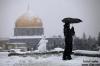
Despite the fact that the 500 hPa level drifts away from us rapidly should not concern us, this storm and overall pattern is very unique to the Levant
For the first time, in a very long time, Jordan, and Palestine will witness something truly special, insidious and potentially Dangerous.
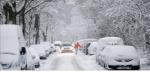
First of all, there will be a period of very heavy snow between 8 am and noon saturday for elevations above 950, yes this personal conjecture but as we just witnessed, when there is strong wind, the snow has less time to melt and change to rain.... temperatures during todays small burst of snow at 850 hPA was certainly did not support snowfall, and going forward, the entire system is a rare breed
After that burst Pali and Jordan will witness something truely special, prolonged non-accumulating light fluffy snow that endures for 48 hours as temps at 850 persist between -3 and -6
Spotty snow, and convective bursts will exist, and by all means, this is not a classical situation. Prepare yourself for a surprise
Sea effect snow sat night and sunday, possibly monday distributed to elevations 600+ in elevation
IT WILL BE DANGEROUS TO DRIVE ANYWHERE BETWEEN ***SATURDAY 4 pm and MONDAY 9 am*** due to the hard freeze of all the rain and slush
Something im truly worried the country is not prepared for, please be careful. if you want to go out and have fun driving in the snow, do it saturday MORNING. the following days will hold "black" "invisible" ice everywhere, especially on bridges, and exploring will be far more dangerous than usually predicted. IT WILL LOOK CLEAR but will be treacherous to handle
Just a word of caution, throw away all your assumptions about 500 and 850 hPA dynamics, and lets be careful. Leave the rest to god, sub7an wa ta3ala
Salam :)
|
Rare participation but always very valuable. When u come here and talk, something happens... same as January last year...
Thanks for the update


 العرض العادي
