|
اقتباس: المشاركة الأصلية كتبت بواسطة جبل الزهور

اقدم لكم هذه الورقة من جامعة كولومبيا
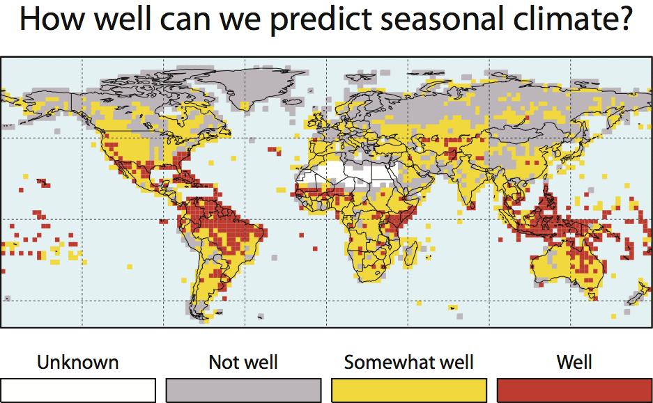
لاحظ منطقتنا ضمن الدقة المنخفضة ولسنا لوحدنا فكثير من مناطق العالم تختلف في دقة التوقعات
|
مساء الخير صديقي محمد والى جميع الأصدقاء في المنتدى ..
بحثت عن هذا الموقع وهذة الجامعة الكولومبية
فهي جامعة تهتم بأمور المناخ ولديها نشرة لثلاثة اشهر (اي طوال فترة الشتاء ) ومهمتها اعطاء الأنذارات المبكرة ..
حسب ما هو وارد في الموقع فالتوقعات دقيقة للمناطق المدارية أكثر من غيرها وهي التي تظهر باللونين الاحمر والاصفر
طبعاً لأن هذة المناطق معرضة اكثر من غيرها لأطلاق انذارات مبكرة فيما يتعلق للطقس ..
This map shows where IRI 3-month forecasts are consistently good at predicting seasonal rainfall for at least one season of the year.
Specific patterns of rainfall that can be predicted 3 months in advance are strongest in the tropical regions, which you can see on this map. If you are in a red or yellow area, we recommend monitoring seasonal forecasts all year long for current confidence levels in predicted rainfall.
حسب الموقع المناطق الرمادية كما يتضح بالصورة هي مناطق غير معرضة لهطول مطري "غير عادي " لذلك يصعب جداً او حسب ذكر الموقع فأن التوقع لهذة المناطق شبة معدوم ...
Red areas show where forecasts can be generally skillful, and so it is possible for us to indicate high confidence for forecasts of unusually wet or dry seasons in these locations. Seasonal forecasts in red areas may be most useful for early warning.
Yellow areas indicate where forecasts have some skill. These are also areas worth monitoring, although we will only occasionally indicate high confidence for these forecasts.
Grey locations are places with little or no skill. Any forecasts of unusual rainfall in these locations will usually only show low confidence and early warning opportunities would likely be limited.
وشكرا لك على اضافاتك المميزة دائما والتي نستفيد منها كثيرا ...


 مساء الخير للجميع استمرار المنخفض الاطلسي بضرب مناطق وسط التوسط و الاوزوري متوقف في عرض المحيط الاطلسي تحت ضربات المنخفض الاطلسي و بداية ظهور ضغط منخفض نواحي ايران و كما قلت ما بعد الاسبوع الاول الامور معقدة جدا جدا و تبقي الامور بين انتقال النشاط الينا و بين استمراره لوسط و غرب المتوسط نشاط الاوزوري نحو اوروبا و موقع السيبيري سيحدد انتقال النشاط من وسط و غرب المتوسط الينا او استمراره هناك


 العرض العادي
